OCEAN STORY #14
Mapping a course for the tug and barge industry
learn more

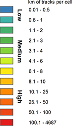
Legend

Tug-Tow Vessels (2012)

Tug-Tow Vessels (2011)

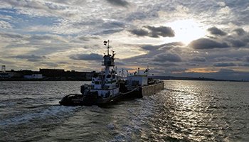
Tug and barge operators move 800 million tons of bulk commodities and cargo like fuel, grain and building materials from port to port along U.S. coastlines each year, keeping our economy afloat. Much of the gas in your car, fuel for heating your home, construction materials used to build new schools, highways and housing developments, and food on your table has spent some time on a barge that was towed from one port to another along the Mid-Atlantic Coast. 

This critically important mode of water transportation is often overlooked. However, it significantly reduces greenhouse gas emissions because it is the nation’s most fuel-efficient mode of moving goods. According to the American Waterways Operators (AWO), the national trade association for the U.S. tug and barge industry, a mid-size coastal tank barge has the capacity to take 523 loaded trucks off the road or replace 167 loaded railcars.  Moving the same amount of cargo by tug and barge produces 20 percent less CO2 per ton-mile than carrying it via rail, and a 90 percent reduction in CO2 emissions compared to moving it via trucks.

The tug and towing vessel operators play a major role in securing our coastal waters, serving as the “eyes and ears” of our marine transportation system to keep our nation’s waters safe in partnership with the Coast Guard. In fact, the tug and barge vessel operators worked with the Coast Guard, ferry operators and other vessels to evacuate more than 500,000 people from Manhattan on 9/11—the largest maritime evacuation in history.

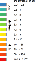
Legend

BOEM Active Renewable Energy Leases
Loading...

Tug-Tow Vessel Transit Counts (2017)
Loading...

Tug-Tow Vessel Transit Counts (2016)
Loading...

Safely navigating the coast and ocean obstacles

John Harms, American Waterways Operators

For the last century, the tug and barge industry has enjoyed relative freedom and autonomy in choosing the most convenient, economical and safest navigation routes for shuttling commodities and cargo up and down the Mid-Atlantic coast. As the ocean becomes busier, obstacles to easily barging goods from port to port are surfacing.

Commercial offshore wind energy development poses quite a riddle for the tug and barge industry. On one hand, offshore wind presents a great opportunity for creating more maritime industry jobs.  Wind developers will need experienced mariners to safely transport enormous objects like wind towers and blades, while the maintenance of these projects requires expertise in operating safety in the marine environment.  On the other hand, wind turbines may create a hazardous obstacle course for some of the most frequented tug and barge navigation routes.

The Bureau of Ocean Energy Management (BOEM) has designated four Mid-Atlantic Wind Energy Areas—Outer Continental Shelf lease blocks slated for offshore wind development—located 12-20 miles offshore in New York, New Jersey, Delaware, Maryland and Virginia waters. Each Wind Energy Area overlaps with traditional nearshore routes that are used primarily by tug and towing vessels. For example, as currently configured, the New Jersey Wind Energy Area would divert vessels up to 20 miles further offshore from their normal route—where weather and currents can threaten the safety of navigation. To better understand these implications of​ the wind energy areas to the shipping industry​,​ BOEM, through the joint BOEM/NOAA MarineCadastre.gov project, is funding the development of Automatic Identification System (AIS) vessel tracking data.​ ​When collected over many months or years, AIS data can illustrate patterns of ocean use by large vessels and help ocean energy planners avoid areas that are likely to cause problems with shipping commerce.

“In certain weather conditions, just one mile further offshore can change sea conditions drastically, putting towing vessels at greater risk and jeopardizing safe transit,” said John Harms, Manager for AWO’s Atlantic Region. “Forcing vessels to deviate from their optimal route will waste up to 100 gallons of fuel per hour, increase air emissions and add hours to transit times, increasing transportation costs and air pollution.”

And yet, if designed with more careful consideration of traditional vessel routes, the AWO is very supportive and optimistic about the future of offshore wind in the Mid-Atlantic. “If done correctly, the projects will be a boon for the maritime industry and fulfill the promise of a clean, renewable and domestic energy source,” Harms said.

Legend

BOEM Active Renewable Energy Leases
Loading...

Tug-Tow Vessels (2012)

Tug-Tow Vessels (2011)

A portal to new opportunities

John Harms, American Waterways Operators

Regional cross-sector collaboration, planning and better information about ocean uses and resources all have the potential to create multiple viable solutions for the tug and barge industry to operate safely alongside wind farms. Aided by the Mid-Atlantic Ocean Data Portal, the AWO and Coast Guard have visualized past and current vessel routes and traffic density for tug and barge vessels (extracted from the Coast Guard’s Automatic Identification System data) in relation to the Bureau of Ocean Management’s Wind Energy Areas to try to identify ways to avoid conflicts.

To best protect the interests of the tug and towing community while enabling offshore wind to flourish, Harms and other industry representatives are taking things a step further: they are working with the Coast Guard to develop “marine spatial planning guidelines” for tug and towing vessels as part of the Coast Guard’s Atlantic Coast Port Access Route Study.  For the first time ever, vessel operators are working together on an innovative approach to develop specifications necessary for the safe and economical navigation of tug and towing vessels along the Atlantic Coast. One of the most obvious types of marine spatial planning guidance currently under development includes creating a “safe navigation corridor” along the Atlantic Coast to ensure the safe and efficient flow of commerce for decades to come.

The state of the sea, the depth of water, the density of traffic, the closest point of approach, and the variability of a vessel’s track (known as “cross track error”) all have to be considered when determining the appropriate dimensions of near-shore routes for towing operations.  Once tug and tow operators have approved a set of marine spatial planning guidelines, these will be made available in the Portal and accessible to all for regional planning purposes, including siting new offshore wind energy developments.